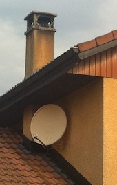

When orienting a TV satellite dish, it's very useful to know in advance the required azimuth and elevation, since the the operation is not easy. A misalignment of one degree is enough to completely loose the signal: trying to find a satellite simply by blindly and randomly moving the antenna has very little chances of succeeding. Just looking at the neighbor's satellite antenna to see its orientation is of very little help.
This tool can be very handy to calculate the exact bearing (azimuth and elevation) of an antenna for a given location (defined by its latitude and longitude), when this antenna is pointing to a geo-stationary satellite located at a given longitude. All geostationary satellites are located at the same hight of 35'800 km, so this parameter is hardcoded in the calculator. The earth radius of 6'370 km is also treated as a constant and hard coded.
Mobile version available here.
To use this calculator, just enter the required coordinates and hit "calculate bearing". The "get current location" button will try to obtain your current coordinates from your browser: it only works if geolocation is supported and enabled in your browser, and works better with devices equipped with a GPS.
If you need to convert to or from Swiss grid coordinates, a converter is available here.
The calculator works for any location on the earth. If you get a negative elevation, this means that that satellite cannot be seen from the specified location, unless you dig a tunnel ;-) Even a positive elevation is not a guarantee for reception, since the line of sight may still be obstructed by mountains, hills, buildings, trees,...
You can directly use the computed bearing on a regular compass and clinometer. Beware that compasses are often fooled by stray magnetic fields, like a slight magnetization of the antenna pole. It's better to take several measurements at slightly different locations to see if there is interference on the magnetic field.
For installing a TV satellite antenna a good military-grade compass, maybe with integrated clinometer, will be your best friend.

To correctly install a satellite dish, start by determining the coordinate of the location, either with a GPS or from a map. Absolute precision is not required here: if you're off by 10 km you'll be fine and it's ok to use the coordinates of the closest city. Obtain the longitude of the satellite you want to receive: on the internet you will quickly find it. For example, the famous "HotBird 6" is located at 13°E. Calculate the bearing with this calculator and orient your dish as precise as you can. Than connect your receiver and with some luck you should already receive a weak signal. If not, try to move your dish a few degrees up and down, left and right until something appears on the screen (you should, of course pre-tune your receiver to a known channel). Once you have your signal, slightly move the dish for the maximum strength (minimum error rate).
Please keep in mind antennas have side lobes: when you think you just found the maximum signal, move the antenna a little further to make sure that you adjusted on the main lobe and that there isn't another position a fraction of a degree away with a stronger signal.
Since satellite dishes are flat and perpendicular to the direction of the waves they receive, it's difficult to see the exact orientation just by standing behind. It's much easier to walk a few steps on one side and look at the rim of the dish with only one eye. Just by moving your head you can easily determine with good precision when your sight is perfectly parallel to the dish, and this direction is 90° apart from the azimuth you want, so the calculation is not too difficult. Furthermore, being a few meters away from the antenna, dramatically reduces the magnetic interference.
This is the equation used to calculate the azimuth of the receiving antenna azrx:

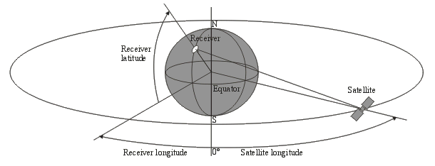
Where latrx and lonrx are the latitude and longitude of the receiver. lonsat is the longitude of the satellite.
And this is the equation used to calculate the elevation of the receiving antenna elrx:

Where R0 is the radius of the earth (R0 = 6'370 km) and h is the height of the satellite (for a geostationary satellite, h = 35'800 km).
The following drawing shows how latitudes and longitudes are defined here:

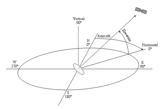
Receiving antenna azimuth and elevation are clearly shown in the following drawing:

| [1] | Calcolo degli angoli di elevazione e di azimut di tutti i satelliti ricevibili. Progetto-Elektor, Numero 4, Aprile 1996, Page 111. |
| [2] | Come ricevere le TV estere via satellite. Nuova Elettronica, Anno 20, Numero 123 (Volume 23), Maggio 1988, Figura 34, Pagina 22 (150). |
| Home | Electronics | Page hits: 140219 | Created: 03.2003 | Last update: 08.2013 |